Hudson Valley
This article is about the region. For the magazine, see Hudson Valley (magazine).
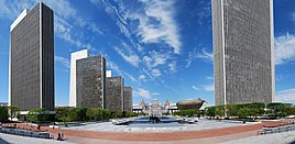
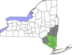
Hudson Valley Region  Farm in Brunswick  Downtown Ossining  Hudson River at Bear Mountain  The United States Military Academy  Getty Square in Yonkers  Kykuit mansion  Empire State Plaza in Albany  Counties most recognized in the region (green); partially recognized counties (gray)[N 1] Country United States State New York Counties Putnam, Rockland, Westchester, Dutchess, Orange, Sullivan, Ulster, Albany, Columbia, Greene, Rensselaer Area • Total 7,228 sq mi (18,720 km2) Population (2013) • Total 2,323,346 • Density 320/sq mi (120/km2) Time zone UTC−5 (EST) • Summer (DST) UTC−4 (Eastern Daylight Time) Part of a series on Regions of New York  hide Downstate New York New York City Long Island Hudson Valley (Lower) hide Upstate New York Hudson Valley (Middle and Upper) Capital District North Country Southern Tier Mohawk Valley Central New York Finger Lakes Western New York show Administrative divisions show Timelines of town creation v t e |
|---|
History[edit]
Pre-Columbian era[edit]
The Hudson Valley was inhabited by indigenous peoples ages before Europeans arrived. The Lenape, Wappinger, and Mahican branches of the Algonquins lived along the river,[2] mostly in peace with the other groups.[2][3] The lower Hudson River was inhabited by the Lenape.[3] The Lenape people waited for the explorer Giovanni da Verrazzano onshore, traded with Henry Hudson, and sold the island of Manhattan.[3] Further north, the Wappingers lived from Manhattan Island up to Poughkeepsie. They lived a similar lifestyle to the Lenape, residing in various villages along the river. They traded with both the Lenape to the south and the Mahicans to the north.[2] The Mahicans lived in the northern valley from present-day Kingston to Lake Champlain,[3] with their capital located near present-day Albany.[2] The Algonquins in the region lived mainly in small clans and villages throughout the area. One major fortress was called Navish, which was located at Croton Point, overlooking the Hudson River. Other fortresses were located in various locations throughout the Hudson Highlands.[3]Hudson River exploration[edit]
In 1497, John Cabot traveled along the coast and claimed the entire country for England; he is credited with the Old World's discovery of continental North America.[4] Between then and about 1609, exploration took place around New York Bay, but not into the Hudson Valley. In 1609, the Dutch East India Company financed English navigator Henry Hudson in his attempt to search for the Northwest Passage. During this attempt, Henry Hudson decided to sail his ship up the river that would later be named after him. As he continued up the river, its width expanded, into Haverstraw Bay, leading him to believe he had successfully reached the Northwest Passage. He also proceeded upstream as far as present-day Troy before concluding that no such strait existed there.[5]Colonization[edit]
After Henry Hudson realized that the Hudson River was not the Northwest Passage, the Dutch began to examine the region for potential trading opportunities.[6] Dutch explorer and merchant Adriaen Block led voyages there between 1611 and 1614, which led the Dutch to determine that fur trade would be profitable in the region. As such, the Dutch established the colony of New Netherland.[7] The Dutch settled three major fur-trading outposts in the colony, along the river, south to north: New Amsterdam, Wiltwyck, and Fort Orange.[6] New Amsterdam later became known as New York City, Wiltwyck became Kingston, and Fort Orange became Albany.[6] In 1664, the British invaded New Netherland via the port of New Amsterdam.[6] New Amsterdam and New Netherland as a whole were surrendered to the British and renamed New York.[8]
Under British colonial rule, the Hudson Valley became an agricultural hub, with manors being developed on the east side of the river. At these manors, landlords rented out land to their tenants, letting them take a share of the crops grown while keeping and selling the rest of the crops.[9] Tenants were often kept at a subsistence level so that the landlord could minimize his costs. Landlords held immense political power in the colony due to driving such a large proportion of the agricultural output. Meanwhile, land west of Hudson River contained smaller landholdings with many small farmers living off the land. A large crop grown in the region was grain, which was largely shipped downriver to New York City, the colony's main seaport, for export back to Great Britain. In order to export the grain, colonial merchants were given monopolies to grind the grain into flour and export it.[9] Grain production was also at high levels in the Mohawk River Valley.[9]
Revolutionary War[edit]

The Hudson River was a key river during the Revolutionary War. The Hudson's connection to the Mohawk River allowed travelers to get to the Great Lakes and the Mississippi River eventually. In addition, the river's close proximity to Lake George and Lake Champlain would allow the British navy to control the water route from Montreal to New York City.[10] In doing so, the British, under General John Burgoyne's strategy, would be able to cut off the patriot hub of New England (which is on the eastern side of the Hudson River) and focus on rallying the support of loyalists in the South and Mid-Atlantic regions. The British knew that total occupation of the colonies would be unfeasible, which is why this strategy was chosen.[11] As a result of the strategy, numerous battles were fought along the river, including several in the Hudson Valley.[12]

Comments
Post a Comment